Useful Emergency Info
Weather Info
|
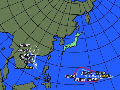
Typhoons : Projected path (Asian region)
|
■ Issued by JMA at 19:20 on Jul 01,2026
| CurrentLocation |
| Location |
Latitude =14.5
Longitude =116.2
|
| Area |
南シナ海 |
| Size |
-- |
| Strength |
-- |
| Maximum wind speed |
15 km/h |
| Direction of movement |
西 |
| Speed |
30 km/h |
| Central pressure |
1000 hPa |
| Maximum storm radius |
-- km |
| Direction of maximum storm radius |
-- |
| Minimum storm radius |
-- km |
| Direction of minimum storm radius |
-- |
| Maximum gale radius |
-- km |
| Direction of maximum gale radius |
-- |
| Minimum gale radius |
-- km |
| Direction of minimum gale radius |
-- |
|
| Information on forecast center position |
| Date and time of forecas |
07/02/2026 06:00 |
| Location |
Latitude =16.2
Longitude =114.2
|
| Maximum wind speed |
15 km/h |
| Direction of movement |
北西 |
| Central pressure |
1000 hPa |
| Radius from the forecast center position |
100 km |
| Maximum storm warning radius |
-- km |
| Direction of maximum storm warning radius |
-- |
| Minimum storm warning radius |
-- km |
| Direction of minimum storm warning radius |
-- |
|
 |
| CurrentLocation |
| Location |
Latitude =10.2
Longitude =161.7
|
| Area |
マーシャル諸島 |
| Size |
-- |
| Strength |
-- |
| Maximum wind speed |
15 km/h |
| Direction of movement |
北北西 |
| Speed |
25 km/h |
| Central pressure |
1000 hPa |
| Maximum storm radius |
-- km |
| Direction of maximum storm radius |
-- |
| Minimum storm radius |
-- km |
| Direction of minimum storm radius |
-- |
| Maximum gale radius |
-- km |
| Direction of maximum gale radius |
-- |
| Minimum gale radius |
-- km |
| Direction of minimum gale radius |
-- |
|
| Information on forecast center position |
| Date and time of forecas |
07/02/2026 18:00 |
| Location |
Latitude =11.8
Longitude =158.9
|
| Maximum wind speed |
18 km/h |
| Direction of movement |
西北西 |
| Central pressure |
998 hPa |
| Radius from the forecast center position |
110 km |
| Maximum storm warning radius |
-- km |
| Direction of maximum storm warning radius |
-- |
| Minimum storm warning radius |
-- km |
| Direction of minimum storm warning radius |
-- |
|
Copyright(C) Mie Prefecture, All Rights Reserved.
Department of Disaster Prevention, Mie Prefecture